I’ve been running a game in the Dolmenwood setting by Gavin Norman for a bit over eight months. Up to now, the PCs have mostly
confined their adventures to the wood. However, when the Earl of Yellow
recently tasked them with kidnapping the Archpriest of Thune (a quest modeled
on the wonderful Kidnap the Archpriest adventure), their escapades forced
me to consider the world beyond Dolmenwood’s shadowed eaves.
Admittedly, before starting our Dolmenwood campaign, I
spent little of my time developing the world outside Dolmenwood’s borders. I
spent most of my time studying Necrotic Gnome’s Wormskin zines like a student
cramming for exams and adding spices to the homebrewed Knave system we use to
run the game. So, when compelled to think about the larger world, my first
instinct was to Google what other people (smarter than me) have said and done.
That’s when I found the compelling Midderlands setting.
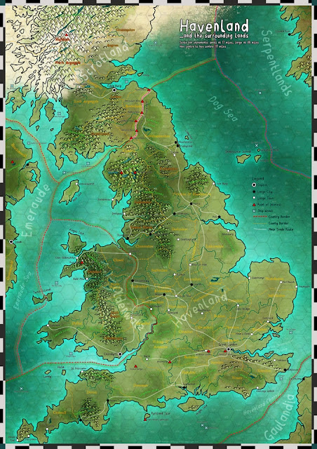
Conveniently enough, the Midderlands provides a place for Dolmenwood in
Emeraude, their mirror-version of Ireland – as you can see below.
 |
| The map included with the Midderlands Expanded. See Emeraude to the west. |
Thus began my quest to fit Dolmenwood into Ireland.
First of all, the Midderlands setting (and the
Midderlands Expanded, which plants the idea of Emeraude) are both fantastic
resources I highly recommend. Although I haven’t used either of them at the table
yet – they were my Christmas present to myself this year, so I’ve had them for
less than a month – they’ve been a joy to read. Simultaneously dark and whimsical,
I think the tone and style of the Midderlands fits Dolmenwood well.
Anyway, when trying to figure out how to fit Dolmenwood
into Ireland, my first step was to assess Gavin Norman’s hex map of Dolmenwood
(pictured below).
 |
| This is a map I colored for my players. You're welcome to use this map too, if you'd like. |
I then compared this map to where Glynn Seal situated Dolmenwood
in Emeraude, pictured below (enlarged to show texture).
Note
that the picture I posted above says each hex is 17 miles from center to
center, but the large poster-map I got with the books says it’s 18 miles per
hex. In light of this discrepancy, we’ll just say it’s 18 miles per hex because
18 isn’t a prime number and I like that.
So, comparing these two maps, it seems as if Bellthorp in
Emeraude is analogous to real-world Belfast in Ireland, and the Manse of
Ygraine (located in the northeast of Dolmenwood) is in Antrim.
At this point, I encountered two problems.
The first is that the rivers in Dolmenwood flow north to
south. The rivers in Northern Ireland, for the most part, don’t do that. They
generally flow from south to north.
(P.S. I’m almost certain that all my recent research into
Irish watersheds, river basins, and hydrology has earned a place on a
government watchlist somewhere).
Now, I realize this is a fantasy game and that I don’t
have to recreate an exact map of Ireland. That’s absolutely fine. However,
saying that rivers flow from the ocean to the inland is a logical leap I’m unprepared
to take at the moment (although it does sound like it would make for an
interesting campaign setting)…
All of you Ireland hydrology afficionados out there (and you
know who you are) might think, “Well alright then, just flip Dolmenwood 180
degrees and make Lough Neagh into Lake
Longmere. Easy.”
Well, that would be fine, if it wasn’t for the second
problem: one of coastline. In sum, if I were to situate the Manse of Ygraine
where Glynn put it in Emeraude, Dolmenwood would just be too big to fit (if I kept
Emeraude to scale with real-world Ireland). Parts of Dolmenwood that are
supposed to be firmly on land would instead lie on the coast or, at the worst,
in the water.
So, in the face of these two problems, I resolved to pick
up Dolmenwood and move it elsewhere in Emeraude. I guess we’ll just assume the
map provided in the Midderlands was made by some addled Midderlander
who’d never actually been to Emeraude, and was really just scribbling
around in the dark with a Gloomium-infused mind. Together, on this blog,
we’ll put Dolmenwood where it really is in Emeraude.
Or, at least, that’s what I’ll tell myself. So congrats, Republic
of Ireland – you get Dolmenwood.
Having decided to situate Dolmenwood in southern Emeraude,
I then set upon a thorough study of Dolmenwood’s rivers and lakes. As you’ve
probably discerned by now, I’m an amateur map enthusiast and creating a
realistic hydrology in imaginary worlds is where I find joy in life.
(Side note: the creek by Prigwort really bothers me on
the Dolmenwood map, as rivers rarely split in real life. The same is true of
Taran’s Run in Creighton Broadhurst’s Lonely Coast setting. I’ve even gone as
far as using Microsoft Paint to edit the offending rivers from each of the maps
for my home games. Yeah, I’m that retentive about it).
Lake Longmere dominates the Dolemenwood hex map. Fed by
several streams from the north, it flows south via the River Hameth. So, I set
out to find a comparable lake in Ireland.
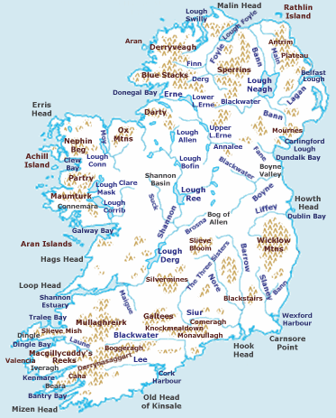
Conveniently enough, I found a map of Ireland’s rivers and lakes on Wikipedia. Even more conveniently, Lough Ree – situated in the center of Ireland – seems about the right size and shape for a mirror version of Lake Longmere.
 |
| The mountains and rivers of Ireland, courtesy of Wikipedia. |
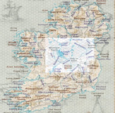
I then imported the map of Ireland to Roll20, allowing me
to superimpose a hex map atop it. Next, I imported the map of Dolmenwood and
tried to find a place it would reasonably fit, after scaling the hexes.
After a bit of finagling in Roll20, the result looked
like this. Pardon the blurriness of the background. I also included an older
map of Ireland, as well, so its coastline wouldn’t exactly match that of
real-world Ireland, only reflect it – funhouse-mirror style.
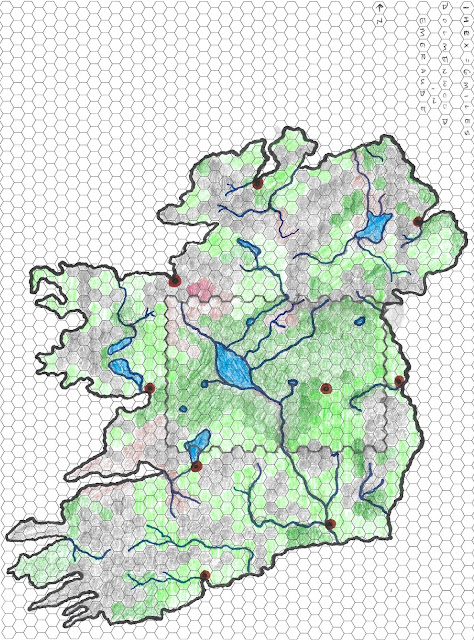
The above map created, I then set upon creating a
hand-drawn version I could present to players without feeling ashamed or
ruining my printer. After several hours with markers, colored pencils, this winter mix of Dungeon
Synth, and diligent tracking of my progress on Microsoft Paint, I arrived
at the map featured below. Please pardon my inexpert rendering. I intend this
to be a springboard for you and your campaign, not so much a final product.
 |
| Ta-da! |
I intentionally left the differences between the dark
green and light green a bit vague, to allow some discretion for what they stand
for – ex. whether the light green is lightly wooded, clear terrain, etc. The
brown represents wetlands or marsh, while the grey represents hills. You can also see where I penciled in what would be the borders of Gavin's Dolmenwood map.
I’ve intentionally left out place names to allow
discretion on your part, again, rather than including the real Irish names (or
the two names provided in the Midderlands Expanded). You’ll see that I’ve
highlighted some population centers in red, however, to give a sense of where
major settlements might lie (such as Brackenwold).
All of you Irish hydrology afficionados who have yet to click
away in exasperation (and again, you know who you are) will recognize a few
changes from real-world Ireland. Perhaps most notably, Lough Ree (or Lake
Longmere) now flows into the Nore, rather than the River Shannon. This is to maintain
the geography established in Gavin’s map of Dolmenwood. It still makes sense,
as the water can thread a valley between Slieve Bloom and the Silvermines. In
short, I accepted everything on Gavin’s map of Dolmenwood as true and modified
the rest of the isle to fit it – rather than altering anything in the
boundaries of the Wood.
Lastly, how does this finished map fit with what we know about
the area outside of Dolmenwood from the Wormskin zines?
Well, perhaps as both a blessing and a curse, the zines
are pretty sparse on information outside Dolmenwood. This leaves a lot of
wiggle room for amateur cartographers, such as myself.
However, we are treated to a bit of a description of the “High
Wold” in issue 2. In it, Gavin says the Wold extends south of the forest for
forty leagues in “rolling hills and rustic meadows.” We also know that High-Hankle,
the seat of administrative power, is south of Dolmenwood. I think we can also
assume that the King’s Highway leading out of Dolmenwood to the east heads
somewhere important.
This fits reasonably well with the map above, if
you squint your eyes and cock your head a bit. Forty leagues, according to
Google, translates to about 140 miles. That, in turn, would be about twenty-three
hexes… which is about the distance from where the River Hameth exits the Dolmenwood
map to the very tip of Macgillicuddy’s Reeks in the south. So, it’s close.
I’m going to guess that Gavin didn’t initially plan on
Dolmenwood being in Ireland (or Emeraude) when he first wrote about it, though
that’s just speculation on my part. Personally, I like how Glynn Seal made room
for the setting in his own Midderlands world. Perhaps we’ll be treated to Gavin’s
take on things in the Dolmenwood campaign book? In the meantime, my players are
on Emeraude. (:


This is such amazing work! I wish I had seen it sooner, as I have (rather poorly) gone through some of the same efforts trying to place Dolmenwood in fantasy England. I settled on Northumbria, specifically setting it in the Kjelder Forest. The lake that I picked was the Kjelder Water (man-made, but similarly sized). River Hameth is basically the North Tyne. I figured the political seat of Duchy of Brackenwold would be Durham but the castle was an ancient family home to guard against the return of *spoilers*.
ReplyDeleteHey, thank you! 😁 That sounds like a great place for it, as well. I imagine it would also fit there!
DeleteThe time frame I'm going for is immediately post-Norman conquest but before the rebellions in the North, that way players can build experience in Dolmenwood but potentially enter the wider world of politics if they so desire. If I'd seen your map I might have used it outright though. I really love what you've done with your hex overlay.
ReplyDelete